|
Why the Planning permission is invalid
by Pauline Bleach
REFERENCE LINKS:
1. Planning Process/Environmental Impact Statement
2. An Board Pleana Case reference: PL17 .MS2004
Meath County Council
M3 Clonee - North of Kells Motorway Scheme 2002
Case type: Motorway Scheme
Decision: Approve with modifictions
Date Signed: 22/08/2003
Parties:
Meath County Council (Road Authority)
As was said in the 1929 national monuments act debate “It is particularly necessary in Ireland to preserve those monuments to get the history of them and to teach all about them, [because] many attempts were made here to poison the wells of history. I think some of the streams of history are to be found in those monuments.”
First, I will deal the failings of the An Bord Pleanala hearing, then I will give you a number of reason why the route should be changed. This only refers to the disputed Drumshaughlin to Navan section of the M3 which goes through Tara and Skyrne.
Failures of Bord Pleanala hearing.
An Bord Pleanala's conclusion was:
“I am satisfied that
all of the issues referred to in the submissions made prior to the Hearing were adequately addressed during the evidence given at the Hearing, and in the cross-examination of the Council witnesses at the Hearing.”
The Council closing submission that “that the Scheme was fully in accordance with law, as being carried out in accordance with the requirements of the law”. Sadly, no assurance that they carried out their job with due care to our heritage.
This seems strange considering the litany of complaints that the wrong route was chosen and the continuing complaints about the lack of information in the EIS. Also as the reasons given for accepting this routing are, as I will explain, in fact incorrect.
“Mr. O'Donnell [Objector on behalf of Dalgan Park] questioned the competence of the various witnesses that had given evidence for the Council on the Drumshaughlin to Navan Section in relation to the approach taken, the level of detail addressed and the conclusions reached and suggested that, in most of the areas discussed, there had been a more appropriate route considered at the route selection stage.”
The Planning Board stated that he “had [not] offered any rebutting evidence“.
Many people objected that the information needed to dispute the EIS was not present in it and the council failed to co-operate in providing it.
The Bord agreed - “This issue is not a matter for consideration in relation to the Road Development itself. However, from the frequency it was raised at the Hearing it is something that the Council might wish to consider in the context of the procedures used when responding to queries from the public, and as a part of their focus on customer service.”
Without information how then can we rebut?
Summary matrices that apparently don't mean anything as stated.
“The considerations used in determining the Preferred Route for each Section are set out in Vol. 2 of the EIS at Section 4.4 and was also outlined in Mr. Guthrie's [Project Engineer from Halcrow Barry for Council] direct evidence at Section 17.1 and each summary matrix has a footnote stating that it is only indicative of possible impacts.
However it is clear from the concerns expressed, [...] that the pictorial representation conveyed by the matrices shown in Vol. 2 of the EIS did not adequately convey the intent of what the authors of the Vol. 2 matrices meant them to represent.”
And weighing processes on the public consultation questionaires that do?
See Public Consultation section.
The Planning Board asked for rebutting evidence but then dismissed complaints that the data needed to rebut was not in the EIS. "I am satisfied that it would not be reasonable to require that the records of the individual borehole, trial pit or corehole logs from the site investigations carried out, or for the detailed results of the geophysical surveys, would be included in the EIS for a road development of this nature."
How can one rebut without information? Apparently the law says “to the extent that such information is relevant to a given stage of the consent procedure”
Who decides what's relevant?
Apparently the law only requires reasons but not proof those reasons are valid since the reasons for choosing the current route above the alternatives were incorrect, as I will show below.
Law:
“where appropriate, an outline of the main alternatives (if any) studied and an indication of the main reasons for choosing the proposed alternative, taking into account the environmental effects;" and...
“I am satisfied that the EIS submitted to An Bord Pleanala presented sufficient information to comply with the requirements of Section 50 of the Roads Act, 1993, as amended.”
“I am satisfied from the evidence in the documents and given at the Hearing that the requirements of Section 50 (2) (d) of the Roads Act 1993, as amended, were fully complied with for this proposed road development.”
Issues raised but not addressed
Shiela Bradley, Dowdstown, Garlow Cross, Navan : “She concluded by saying there was a black spot in the valley where the motorway was to be built from the summer fog that regularly occurred, which she felt would cause accidents on the road.”
This fog would severely affect the Blundelstown interchange set low in the valley. Evidence that shocked me seeing the pile up on the M7 due to fog earlier this year. This evidence was ignored by the Bord.
The Orange Route.
“Mr. Guthrie [Project Engineer for Council] replied it was a process of elimination, that the routes to the west of the N3 had slightly better characteristics but as these routes went through the Tara zone of influence, they were rejected on archaeological grounds which left them with groups that went east of the N3, the blue and pink routes.“
But only the routes to the West of the N3 and East of Tara had this rating. The Orange route to the west of Tara was not through any zone of influence, this was carefully not mentioned and conveniently placed in the same basket as those that were too near to Tara. The severe negative rating of the Orange route for archaeological reasons was never explained or addressed in the Planning Bord's conclusion.
Public Consultation
“Mr. Magee [Objector Meath Road Action Group] asked for proof of the residents being a major factor in the decision and Mr. Guthrie said the proof was in the conclusions of the report since they had selected the blue route in preference to the pink route.”
All participants complained about the lack of transparency and information in the consultation process.
“However, a number of people at the Hearing made the point that they had been consulted about a dual carriageway proposal and not about a motorway and suggested that the motorway was a very different concept to what had been shown, as they perceived it.”
Mary Begley, Tara referred “to the Council's response [on] their confirmation of the scheme being presented to the public as a dual carriageway with the decision to make it a motorway only coming after the EPR was arrived at."
Indeed, if it had been proposed as dual carriageway, I think most people, including me, would think expanding the N3 would be a good idea. 2 for 1 for this part of the route is one of the alternatives offered by protesters.
Mr Guthrie [Project Engineer for the Council], acknowledged this “Mr. Guthrie outlined the Route Selection process followed and said that many alternatives for the motorway/dual carriageway..."
The current route was the second least preferred route in the process. Questionaires were missing.
“Mr. Guthrie said there was some weighting applied to the results since they found some people voted for more than one route, with four corridors between Tara and Skreen and one east of Skreen and one west of Tara and that approximately 30% voted for east of Skreen, 30% for west of Tara and 40% for the central corridors.”
So, 60% of people chose the 2 routes outside the Tara Valley. The 4 routes in the valley only got 40% of the votes.
back to top
Thomas Hamill [Objector Bellinter Residents Association] said “the list of completed questionaires supplied to the NRA showed a total of 319 but it did not include Mr.Magee's [Objector Meath Road Action Group] completed questionaire. He said there was a discrepancy of 26 from the figure of 293 given in the Route Selection Report, and asked for an explanation of this.” This was not fully addressed but as we see below, that doesn't matter.
Mr. Guthrie explained “people voted for more than one route and not for another, [...] so they applied a straight weighting of 6 through to 1 for first choice as the fairest way to do it. Mr. Hamill said that might be a statistician's way but he felt if you put down route 1 as your first choice that was it and all other routes were of lessor importance.”
Mr Hamill also stated “that it was also stated the preferences of those favouring Routes E or F were double any other option but said his analysis showed first preferences of A as 75, B as 9, C as 17, D as 7, E as 34 and F as 64. “
So that would make A (Orange route West of Tara) as most preferred first preference and F (Pink route East of Skryne) as second on first preferences. The central corridors, B and C (Green Routes East of the N3) and D and E (Blue routes west of N3) seem startlingly less popular.
Since weighting was not done by the normal accepted Irish method of “proportional representation” where unpopular first preferences are redistributed, we are confused to the real intention of people, though their first preference is enlightening. This anomaly was accepted by An Bord Pleanala as the Council representative Mr Butler explained that there “was no requirement in law for what had now developed as public consultation.” He further submitted on due process "that guidelines were guidelines and were not strictures or statutory requirements."
A bit Pirates of the Caribbean isn't it ;) So lets forget Mr Guthrie's remark about “residents being a major factor in the decision."
What then? Mr. Guthrie said “the pink route was second best with the orange route and there was also the impact on communities in the Skryne and Oberstown areas and that there was little to choose between the routes."
So we can ignore all other routes other than Pink, Orange, and Blue. Both Pink and Orange are acceptable to protesters. Pink would include very little chance of monuments as all archaeologists agree but Orange is seen as a better route for catching both Trim and Navan catchments and mimicking the rail line.
back to top
Factors on which the Route decision was justified by.
An Bord Pleanala -
“The conclusions reached were that the Preferred Route impacted significantly less on houses with only 5 houses within 100 metres while all other routes had higher numbers of houses adjacent to them and there were also lessor impacts on flora/fauna habitats and potential archaeological sites on the Preferred route by comparison to the alternatives considered. I am satisfied that possible alternative locations for a route for the motorway in the vicinity of Dalgan Park and of Ardbraccan were given adequate consideration by the Council in the selection process for the route.”
So lets refer to the EIS since the Summary matrix puts all routes equal for Houses and Private Residences
Houses and Residential Properties
EIS – Route Comparison Volume 2 Section 4.4
Section 4.4.3 Dunshaughlin to Navan Bypass
“This option requires two dwelling houses to be demolished, one small cottage and one uninhabited cottage. This is common with routes Blue 1 and Green 1. The remaining routes all pass in close proximity to existing dwellings which may require demolition. The number of dwellings involved would be similar to Option Blue 2" [Note: Chosen route]
“All routes have a similar but small number of houses, ranging from 2 to 8, within 50m of the centreline of the proposed road. The Blue 2 option is at the lower end of the range with a total of 3."
“For houses located within 100m of the main road centreline, Option Blue 2 is comparable with the other routes considered (13 No) with only Orange 1 and Pink 1 (8 No and 10 No respectively) having a lesser number."
“However within a 200m band either side of the new main road route Blue 2 has the least number of houses affected (44 No). The 200m band is significant in that it is the practical limit where properties may be affected by changes in noise and air pollution”
But the Bord Pleanala's decision was that only 5 houses with 100m, patently false unless we consider it within the 50m zone. In the 100 metre zone we actually have stated in the EIS that there are more houses in range of the Chosen Blue route than the Orange route or the Pink route. The routes preferred at public consultation.
I cannot find information on how many houses are in the 200m zone but when all routes get a “minor positive impact for residential/private properties in the Summary Matrix” we can assume that all routes have a similar small impact.
An Bord Pleanala's conclusion or the EIS is patently incorrect therefore invalidating the planning premission.
Flora/fauna habitats
An Bord Pleanala's second conclusion that supports choice of the Blue route. Once again I refer to the EIS.
4.3.3 Section 2: Dunshaughlin to Navan ( P40)
“With respect to other environmental considerations, Flora and Fauna, Land Use, Geological and Community Facilities and Severance, all four corridors have similar impacts”
I think it is clear for this there is a conclusion that all the routes have a similar impact. Nothing was mentioned that actually distinguishes them. So how did Bord Pleanala come to this conclusion. 500 pages later, I'm still not sure.
But I think we can disregard Flora and Fauna as a reason to choose the Blue Route over the Orange or Pink.
Potential archaeological sites on the Preferred route by comparison to the alternatives considered.
The reason according to Mr Guthrie that the Orange route wasn't chosen. The Orange route's still unexplained severe archaeological rating in the summary matrix.
Ms Gowan representing the Council, the route selection and EIS
Ms Gowan represented her own company which was responsible for the archaeological report on route selection. Ms Gowan [For the Council] explained “that her firm was involved in the Constraints and Route Selection and EIS stages but that the EIS had been conducted by Dr. Annaba Kilfeather who had since moved to the Discovery Program.”
Mr Magee [Objector Meath Road Action Group] questioned Ms Gowan why the Orange route had a severe archaeological rating when no other route had been given this. This effectively eliminated this route from consideration according to Mr Guthrie.
“Mr. Magee then referred to a report prepared by her firm for Halcrow Barry dated 14 August 2000 ' N3 to Dunshaughlin Route Selection Archaeology' and to the references to Route O [Orange route] on page 25 in Section 6, quoting from this as saying 'At first glance there are relatively few known archaeological monuments along this route. However the route does pass through an area of enormously high archaeological potential' "
back to top
Mr Magee wondered what this was based on?
Ms Gowan replied “that anything close to the Hill of Tara and close to the Boyne catchment had enormous potential.”
When pressed that all routes should have the same comment she replied “that Conor Newman had suggested there was much more work to be done in the area west of Tara and archaeologists felt the area to the west of Tara was more sensitive and likely to produce a greater potential in terms of low ground remains“
So the only proof offered for this severe archaeological rating for the Orange route was Conor Newman's work.
Mr Magee then stated “the MRAG's objection to the M3 was that the wrong route was chosen and he suggested he had proved this with regard to archaeology and proved that in the route options there was a clearly more viable route than the EPR.”
Ms Gowan replied “that was from an archaeology perspective.”
So this was not the preferred route Archaeologically. Pink was, but the Orange which was a strong contender in every other section was given a severe archaeological rating apparently based on Conor Newman's work.
Once again the complaint of lack of information was raised
“Mr. Magee said they had felt the archaeological aspects of the Navan to Dunshaughlin Section Constraints Report was weak with little detail and when they got sight of the Navan By-pass Constraints study they were amazed to find a 76 page report which basically dealt with the Tara area.”
Core Zone argument
Fr. Pat Raleigh, [Objector St. Columbans, Dalgan Park] stated that “he, as a lay person, found it incredible from a cultural, social and historical viewpoint that a road would destroy a heritage which, once destroyed, could never be restored.”
Ms Gowan replied that “the route had sought to avoid the core area of Tara to a significant degree and had taken Conor Newman's work into account in avoiding his identified core area as well” and that “that Skreen was part of the outer zone in Conor Newman's study area.“
Mr. O'Donnell [objector on behalf of Dalgan Park] suggested “Conor Newman would be Ireland's leading expert as far as Tara was concerned”
Ms Gowan “agreed and said he had had so much experience of working on the Hill.“
Mr. O'Donnell suggested that “Conor Newman's expertise included geophysical perspection techniques as well as Tara itself”
Ms Gowan “agreed his success on Tara had influenced their decision to use geophysical perspection methods on the route with a high level of success following from this.“
Ms Gowan also admitted that her personal opinion on the Blue route she was defending was "that the effect of this route on the Hill of Tara and its outlying monuments is profound and would have severe implications from an archaeological perspective"
and that that had not changed.
Conor Newman - Objector on behalf of himself and the discovery Project. He had been Director of the Discovery Program's Tara Survey since 1992.
So what did Conor Newman, who as we see above was referenced by every proof offered that this was the better route, say at the tribunal?
“He said he was also representing the views of the Council of the Discovery Program as a member of that Council nominated to do so.”
back to top
On the Route Selection
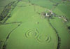
He said “all of their researches pointing to the valley between Tara and Skreen as an area of paramount importance throughout the history of Tara."
“He said it was then not surprising that from the very outset this [Blue] route was identified as the least desirable from an archaeological viewpoint, since the attrition rate on the archaeological heritage would be far higher than for any of the other possible routes. He said that was not only his conclusion but was that of the Archaeological Consultants involved in the route selection process and that it was surprising that the NRA had persisted in selecting this as the preferred route.”
“Conor Newman had written in submission to An Bord that the valley between Tara and Skreen was 'chock-a-block with archaeological monuments' and interesting and complex ones at that."
So according to him, the EIS should rate the Blue routes higher than the Orange route meaning the EIS matrix which rates the Orange route to the west of the valley as severe is incorrect since this only has a “high potential”. Like many of the protester I support the Orange route a fair compromise between progress and heritage.
On the Valley between Tara and Skyrne
“He said people did not generally live on Tara but they buried their dead there and built temples there and lived in the immediate hinterland in the shadow of their sacred mountain. He said that was why archaeologists and historians were concerned about any developments within the vicinity of Tara, with all of their researches pointing to the valley between Tara and Skreen as an area of paramount importance throughout the history of Tara which, he said, was spectactularly [sic] corroborated in the geophysical survey carried out as part of the EIS.”
“He said that Tara dominated documentary sources from Early Medieval Ireland, which was why the proposition in Section 4, sub-section 4.1 of Vol.4 in the EIS that the monuments directly threatened by the motorway were not of prehistoric date was fundamentally flawed.“
On Tara
“He said that the way it was managed would become the yardstick by which our reputation as guardians of cultural heritage would be judged. “
On the EIS
“So the EIS fell short of the amount of preparatory research expended for the proposed motorway near Stonehenge”
On supposed consultation with the Discovery Program “he had checked with the CEO of the Discovery Program and was told that they had no record of a formal approach by Margaret Gowan & Associates and said that Dr. Grogan was not nominated to formally or informally speak for the Discovery Program and that any responses he made would be his own personal comments.” Only Mr Newman was to officially represent the Discovery Program and that was to object to the route.
“He repeated his statement that providing interpretive drawings was inadequate, since it removed the possibility on independent assessment.”
On Geophysical surveys
He said “that the only certainty was that they were there, they were big and complex and that they obviously had a relationship with Tara as prehistoric temenos, Early Medieval
inauguration site or Medieval manor.”
He said “geophysical survey between Tara and Skreen had been carried out in "scan" mode [...] said the technique was standard but had its limitations.“. “He said that the geophysics was simply saying that there was going to be trouble, rather than saying that the decks had been cleared."
Recommended that the “entire route from Dunshaughlin to Navan in a full survey mode, [...] said that would only have confirmed there were even more monuments there and would confirm that an archaeological landscape was being cleaved in two which, he said, was unacceptable.”
He commented on how alluvia disturbed Geophysical surveys
“references to the lack of alluvium might be applicable to the overall length of that section of motorway, but was not true for the area between Baronstown and Blundellstown which, he said, was physically between Tara and Skreen and was of the utmost archaeological sensitivity.”
On the most important Core Zones
“Mr. Newman said references in the EIS and ancillary documentation to the "inner" and "outer zones" from his 1997 book on Tara were unrelated to the so-called "protected zone" and they were related to the budget and time management constraints of the Tara survey and he regretted that they were now being used in the way they had been.”
back to top
In Conclusion
“Mr.O'Donnell then suggested to Ms Gowan that, from an archaeological point of view, her evidence to An Bord should be that they would have particular regard to what she had said about this route having a severe implications on the archaeological perspective”
“Ms Gowan replied that she would expect An Bord to take that into consideration since it formed part of the documentation before them."
So even the archaeologist defending the route cannot in sincerity defend it. She only says other factors made the decision to choose this route.
So far we have no proof that this route was chosen on the correct archaeological basis as stated since all data referred to was Conor Newman's and the Discovery project who both objected.
Bord Pleanala reached the conclusion -
On Routes
“Essentially the objectors case is that a different route [...] that would have "removed" the potential impact from the Hill of Tara archaeological landscape. In this regard it has to be noted that no similar geophysical survey was carried out on a potential route [...] so that an exact comparison of 'apples with apples' can not be drawn.”
In such an important area, surely, they should have requested a geophysical survey on the three most likely routes (Orange, Pink and Blue). This would not have been unthinkable and have saved much discussion later. The opinions of a respected expert who has studied Tara for 18 years should have a lot of weight.
“Having regard to all of the evidence given at the Hearing and the cross-examination on the archaeology impacts in the Tara / Skreen area presented at the Hearing and to the details set out in the EIS, I am satisfied that the route as proposed would not have a significant impact on the archaelogical landscape associated with the Hill of Tara, as indicated by the area designated as the core zone on the RMP Map SK 500.”
The Core Zones that as Conor Newman explained “were related to the budget and time management constraints of the Tara survey and he regretted that they were now being used in the way they had been.”
The Planning bord based their judgement on a “Core Zone” fact they were told was incorrect, making the planning permission invalid.
So it seems that the third reason for not selecting either the Pink or Orange route has come down to the Planning Board taking the justifications given by an archaeologist, who admits that her personal opinion that the route is disastrous for Tara, over the objections of the person who she admits is the foremost expert on Tara, upon whose work the justification for the route was based, that his work was misinterpreted.
I am sure any reasonable person would have agreed that this section of the EIS should have been revised with the help of the discovery project and two more geophysical surveys commissioned. Or at least one to justify the severe rating of the Orange route over the Blue. This is the least needed to justify the Planning Bord's decision.
Thus, I contend that the reasons given for choosing this route over the alternatives do not stand up to scrutiny and therefore the planning permission is invalidated.
Work should be stopped immediately on the Drumshauglin to Navan section. And a geophysical survey done on the Orange route which is supported by Conor Newman as a viable alternative.
back to top
|